I find it noteworthy that there has been no intelligent reply to
my earlier post:
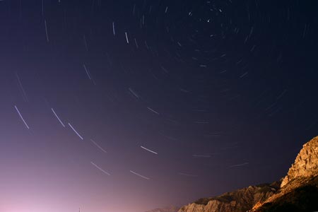
This time exposure shows star tracks from Ogden, Utah, at 41 degrees latitude:
source[/url]]
In the north, the motion is most interesting. Stars rise in the northeast and set in the northwest, moving in counter-clockwise circles around a point that's high above the northern horizon:
Half-hour time exposure facing north and slightly west, from the same location as the previous three photos [Ogden, UT, 41 deg. lat.]. The stars are tracing counter-clockwise circles, centered on a point near the prominent North Star (Polaris). Notice the Big Dipper at the lower-left.
The majestic motions of the night sky were intimately familiar to ancient people. Today this familiarity has been lost (except by astronomy geeks), so you'll need to make a special effort to remember and visualize the patterns. It helps to stand under the night sky and point with your hands, tracing out the paths of different stars. In summary:
Some stars rise directly east, heading to the right, then cross the high southern sky, and eventually set directly west.
Other stars rise in the southeast and follow shorter, lower arcs across the south before setting in the southwest.
And in the north, there are many stars that never rise or set at all; these “circuмpolar stars” follow counter-clockwise circles. (In fact, it is the center of these circles that defines what we mean by “north”.)
...Measuring Angles
When we talk about the apparent "distance" between two points in the sky, we're really talking about an angle, measured between the two imaginary lines running from your your eye out to those points:
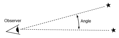
The angle between two points in the sky is defined as the angle between two imaginary lines running from you out to those points. For the two stars shown, the angle is about 16 degrees.
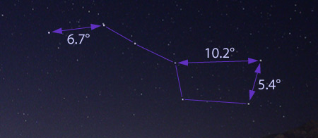
The bowl of the Big Dipper is about 10° wide and 5° deep. The entire handle is 16° long, and the whole Dipper is 26° long.
Similarly, the width of Orion's Belt is a little under 3°, and the four star-trail photos above each span a width of about 60° from side to side.
To measure the angles between stars and other points in the sky, astronomers use protractors and similar instruments, often attached to a telescope for accurate pointing [e.g., sailors use a sextant which is a protractor telescope combination]. To get an approximate measurement, however, you can use instruments that are always with you: your hands. The width of your fist, held at arm's length, is about 10°, while the width of your little finger tip, also held at arm's length, is about 1°.
The rate of angular motion is the same in other parts of the sky, although you can't just measure the angles with your hands because you're not at the center of the circles. In the northern sky, however, you can measure the angles directly by laying a protractor down on a photograph. Here's a longer time exposure of star trails near the North Star:
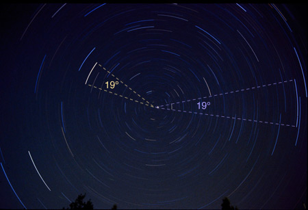
In the northern sky, all stars move at the same rate around the common center of their circles. During this 75-minute time exposure, the stars rotated by approximately 19°.
To simplify their understanding of the motions of the sky, ancient people invented a mechanical model to explain these motions. We still use this model today because it's so convenient... If you can visualize the model, you won't have to memorize a whole bunch of separate facts about how the stars move.
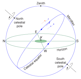
The stars appear to be attached to a giant celestial sphere, spinning about the celestial poles, and around us, once every 23 hours and 56 minutes.
The model is simply that the stars are all attached to the inside of a giant rigid celestial sphere that surrounds the earth and spins around us once every 23 hours, 56 minutes. The spinning carries each star around in its observed circular path, while a special point in the northern sky, at the center of the circles, remains fixed. The sphere's rigidity accounts for how the shapes of the constellations never change, and its enormous size accounts for how the constellations never grow or shrink, as they would if a particular point on earth were significantly closer to one side of the sphere than the other.
To better describe locations in the sky, we give names to the various parts of the celestial sphere. The fixed point in the northern sky is called the north celestial pole, and is located only about a degree away from the famous North Star (which makes tiny circles around it). Ninety degrees from the pole is the celestial equator, a great circle that runs from directly east to directly west, passing high above our southern horizon. Mintaka, the rightmost star in Orion's Belt, happens to lie almost exactly on the celestial equator, so you can think of the celestial equator as tracing the path of this star. Another important great circle is the meridian, which runs from directly north to directly south, passing straight overhead. As the sphere turns, the meridian remains fixed in the sky. The point straight overhead is called zenith.
The Stars from Other Locations
I've described the stellar motions as they appear from my home in Ogden, Utah, at a latitude of 41° north of the equator. What about other locations?
Moving east or west makes no difference, except to determine when you see things. If you live farther east, you'll see any given star rise and set sooner; if you live farther west, each star rises and sets later. We compensate for these differences, in an approximate way, by setting our clocks according to different time zones.
Moving north or south is more interesting. The farther north you go, the higher in the sky you'll see the north celestial pole and the stars around it—and the lower all the stars will appear in the south. In fact, the angle between your northern horizon and the north celestial pole is precisely equal to your latitude.
For example, in Ogden the north celestial pole is 41° above my northern horizon, but if you're in Anchorage, Alaska, the angle is 61°. At the earth's north pole, you would see the north celestial pole straight overhead, and the celestial equator would lie along your horizon, so you would never see any stars rise or set; they would just move in counter-clockwise circles if you're facing upward, or horizontally to the right if you're facing the horizon. Stars below your horizon (that is, south of the celestial equator) would always be hidden from your view.
On the other hand, if you travel south to Mexico City, you'll see the north celestial pole only 19° above your northern horizon. The Big Dipper will no longer always be visible, setting in the northwest and rising in the northeast instead. But in the southern sky, you'll see stars that are never visible in Utah, including the famous Southern Cross.
Farther south, at earth's equator, the north celestial pole lies on the northern horizon, and the celestial equator passes straight overhead. From here, as the constellations rise in the east, they appear to head straight up, rather than along a diagonal. In the west, they head straight down as they set. Even more stars are visible in the southern sky, making clockwise half-circles about a point on the southern horizon, the south celestial pole.
From the southern hemisphere, you can't see the north celestial pole at all. The south celestial pole, however, will appear above your southern horizon, by an angle equal to your southern latitude. Stars rising in the east will head upward and to the left, toward the northern sky. The celestial equator will also pass through the northern sky, lower and lower as you head farther south.
The point of this quote is that from Ogden UT, or any other point on the 41st parallel, Polaris will always be 41 degrees above the visible horizon. Of course, you must be able to identify the horizon, which is easy on a very flat plain of which there are many in the midwest USA. Otherwise, the open ocean is a good place to see the horizon.
When you move north to say Anchorage, AK, the measurement is 61 degrees, as it is at any other place on that parallel around the world.
At the North Pole the north star (Polaris) is directly overhead at 90 degrees.
When you move south to Mexico City, the measurement is 19 degrees.
The explanation for all these effects is simply that the earth's surface is curved.
Conversely, if the earth's surface were flat, there would be no different measurements like these,
the Southern Cross would be visible in the northern hemisphere and the north star would be visible in the southern hemisphere.However, in fact the Southern Cross is not visible in the northern hemisphere, and Polaris is not visible in the southern hemisphere. The reason this is true is that the earth is spherical (approximately).
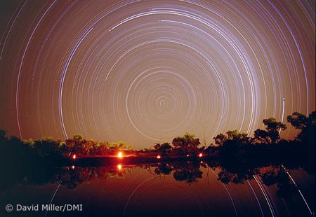
This several-hour-long time exposure, taken from tropical northern Australia, shows the clockwise motion of the southern stars around the south celestial pole. The trails of the Southern Cross start at the top of the image, with the top of the cross initially above the edge. Photo by David Miller/DMI.
Finally, if you visit earth's south pole, you'll see the south celestial pole straight overhead, with the stars making clockwise circles around it. The celestial equator will lie on your horizon, with the stars moving parallel to it, from right to left. You always see the same half of the celestial sphere, completely distinct from the half that you would see from earth's north pole.
In the southern hemisphere navigators use the Southern Cross instead of the north star, because the latter cannot be seen from south of the equator at sea level. At the equator, Polaris appears to be just on the horizon due north, and the Southern Cross rotates (clockwise) due south.
Some flat-earther in a previous thread claimed that the north star can be seen up to 20 degrees south of the equator but provided no reference or evidence of this. Perhaps it is visible from the highest peaks of the Andes mountains, but most certainly not from the surface of the ocean or anywhere close to sea level. The curvature of the earth at the equator prevents a view of Polaris south of that latitude.
So when you travel to a different location, your horizon tilts with respect to the stars. Today every school child is taught that the earth is (approximately) a sphere. Even in ancient times, however, astute travelers realized that the changes in the stars as you travel north or south must be caused by the curvature of the earth. The ancient Greeks even reasoned that the earth must be a sphere, and thus pictured the universe as a pair of spheres: an enormous celestial sphere, carrying the stars around us once a day, and the much smaller spherical earth, fixed at the center of the universe.
The ancient Greeks used this principle to estimate the diameter of the spherical earth, and they got surprisingly close to the reality. They measured shadow of a vertical pole at each of two locations at the same day of two years, since it took them about a year to travel to the second place in the south. This same experiment has been done in our time as well, and the same results are obtained, since the earth's axis has not changed (appreciably at least) since the time of the Greeks.
 Topic: 50 Plus Reasons The Earth Is Not Flat (Read 341366 times)