.
Maybe you know someone who has climbed Mt. Whitney. Every year over 1,000 people do it, many of them under 16, and a few have been under 10. I met one of them on a plane flight from Frankfurt Germany to Los Angeles, nonstop, in 1985. He sat right next to me. He was at that time the youngest person to climb to the summit, and had been listed in Guinness World Records. As I recall, he had been 7 or 8, and when I met him he was 9 or 10. It is a strenuous climb, but if you're in reasonably good condition and you get started before daybreak, you can climb to the summit, slowly, spend an hour looking around, and leisurely (not TOO much so) hike back down well before dusk. This is assuming your starting point is Whitney Portal Campground, which is at 12,000 ft.
There are people who claim to have hiked from the parking lot (8,360 ft) to the summit (14,497 ft. -- 6,137 ft. gain) and back again, a distance of 22 miles, all in one day.
HERE is a website that describes it. I would not recommend attempting that unless you have a LOT of experience and maybe can do the Triathalon or the Iditerod or finish a marathon in the top 25%. Going downhill is kind of like running a marathon, but climbing uphill is like running two marathons. So figure on three marathons in one day, but you can finish in the slowest 10%, okay? Marathons are on pretty level ground. Uphill over 12,000 ft elevation is a whole 'nuther story. There are 99 switchbacks in the Whitney Portal trail, and that doesn't include the ones in the access road, below.
During the winter, there is no access to Whitney Portal, due to snow:
Here is a photo from a website describing a bicycle race to the Portal parking lot, which is at 8,360 feet elevation above sea level:
 http://adventuresonabike.com/2008/06/10/day-2-horseshoe-whitney/
Here is a distance shot of the switchbacks going up the cliff- this is the access road to Whitney portal:

The switchback at the bottom is two miles long. I walked down that whole thing in one afternoon, and I thought my legs were going to fall off. Seriously. Nobody would stop to give me a ride. I had parked my car 15 miles north of there to hike in from a different access point, so I didn't need to get a Whitney Portal permit. Those are just for going UP this front road. I was going DOWN.
The road from Lone Pine to the top of the access road to Portal is a serious ride for a bicycle, probably about 3 or 4 hours' worth, if you're in SHAPE. It took me 6 hours to walk down it.
All in all, it's a 3-day trip, beginning from the parking lot at the top of the road, and hiking uphill over a moderately easy trail to the campground in about 3-5 hours. No motor vehicles are allowed. Motorcycles could ride to the Campground, but you'd be arrested, I'm sure. Probably by helicopter and the S.W.A.T. Team. It's popular to make that a late morning start, but the earlier you start the more you'll get out of your hike. I recommend starting before the sun comes up, because you can experience the changing light all around you in the mountain setting. It's really very much worthwhile. Ansel Adams made a lifetime career out of hiking in the Sierras and his most amazing photographs were taken early morning.
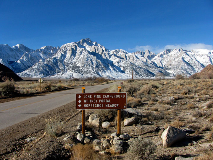
Mt. Whitney viewed from the Lone Pine Ranger Station:
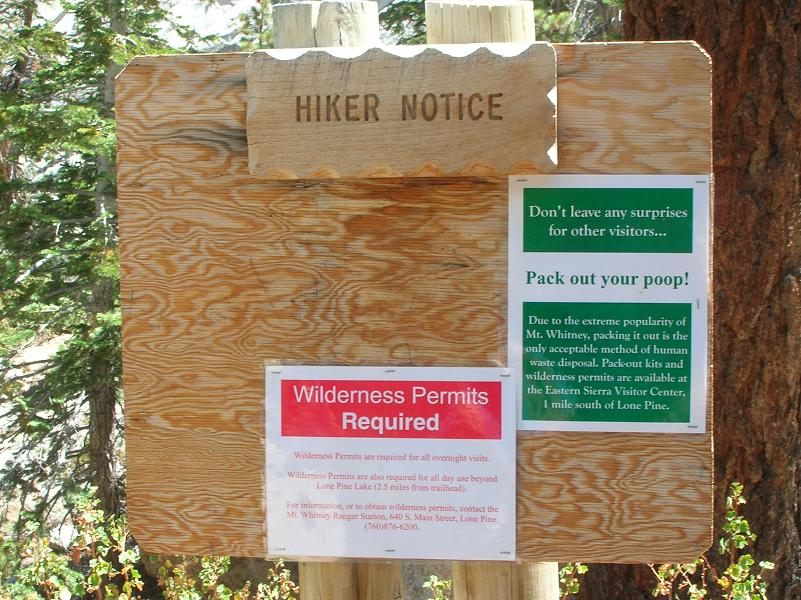
You need to have a Park Service Camping Permit to hike to the campground. There is a very long waiting list, so plan this a year in advance. They don't want just anyone showing up on a whim. It's a serious commitment.
Pack out your poop!
The photography opportunities are astounding. This photo is about 7 degrees leaning to the right:

from the Whitney Portal above Lone Pine.
Photography by Brian Petersen at www.brianapetersen.comEmail Brian Petersen for licenses regarding this image. (Links to a nice website on hiking Whitney Portal)
See that nice, virgin, powdery snowfield on top of the mountain? There
are ski slopes in the Sierra Nevada, but this is not one of them (anyone who skis this had better bring a hang-glider, or at least a parachute):
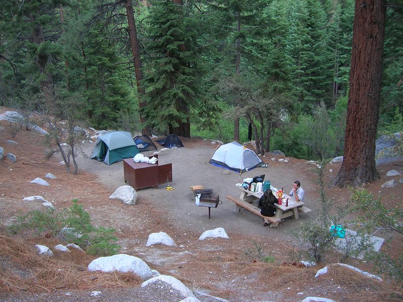
The campground is a beautiful place, and you'll find it's a great place to return to, after you've been to the "other side of the mountain." The big, brown box with the open door is a steel cabinet with a bear-proof latch, so you can keep your food safe inside it. No refrigeration required! Be prepared to hear some banging at night if anything smells good in there. Hopefully, the wild animals won't bother your tent.
Do Not Keep Food or FOOD WRAPPERS inside your tent.
Pay close attention to what the Rangers tell you about food storage and the bear problem. The latest news is important, because bears didn't use to be much trouble but now with all the environ-
mental-ists afoot, it's becoming a come-back time, or, should I say, "pay-back time?"
"
Whtiney Portal Campground and Bear Box - Site 39"
When you arrive at the Campground, you have to follow the rules, and there might be reserved camping sites, so then you have to use what is reserved for you. Get your tent set up before it gets dark, unless you like unpleasant difficulties. It can rain any time up there, so you'll be happy to have a tent to keep dry. Wet and cold is no fun, and it can be fatal. But the danger aspect is a major attraction, for those who want to see what life is REALLY like.

You should retire early to get good rest, because you might not sleep very well, and it takes extra time to relax in this thin-air environment. At 12,000 feet, you're higher up than just about any village in the world. You get winded fast under exertion, and sleeping is not so easy. If worse comes to worse, you just can't sleep, and it's not cloudy or inclement, you can sneak outside and look at the stars, which are pretty amazing up there. Bring a pair of 7x35 binoculars and see if you can count the stars. Good luck!
Waking up two hours before sunrise, you'll find you're not alone. Some of the other 50 to 100 campers in the area might already be on the trail going up to the summit, using portable lanterns. But for them, the switchbacks can be perilous, for water leaking down the slopes at night can freeze, leaving ice patches on the trail. Every few years someone dies by slipping on the ice, and tumbling down the slope to the side. I met a man who knew two boys who were standing there on this trail as they watched their own father slip and fall to his death, right in front of them. That was about 5 years ago. But if you are careful and well-prepared, it's safe. You might need to wear ice "
crampons" for very early ascents.
Bring food and water with you, and a good coat. A day pack with emergency supplies is recommended by the Ranger. It should have fire starter, kindling, space blanket, waterproof matches, a quart or more of water, some dried food or nuts or Cliff Bars, maybe some fruit. You should not think these things are funny because when you're stranded and desperate, it's nothing to laugh at. Keep in mind you might need to help someone ELSE who had thought it was funny.
The ascent to the crossover where you pass the Continental Divide takes anywhere from two hours to five hours. If you really do it s-l-o-w-l-y, it can be longer than that, but at some point, you'll be facing the no-return point, when you'll have to stop, enjoy what you can see for a minute, and then turn around and head back down, because the summit is too high for this attempt. It takes a lot of gumption to know when to say when, and it can be a very foolhardy move to just keep on climbing, come what may, because it WILL come. There are only so many hours in the day.
I'm pretty sure this is a photo of the back side of the Continental Divide, looking NorthEast:
 Here is a website with some helpful camping information
 (The words are in a tiny window with a scroll bar on the right.)
When you cross over the Divide, you're on the West side of the ridge, and the panorama changes entirely. You can see the interior of the Sierra Nevada high country from there, which includes grassy meadows with meandering streams full of extremely delicious trout. And they know how good they are. If you want to climb down to that, it means you had to bring your full backpack and sleeping gear and tent with you, because it's a 5-hour round trip, at minimum, meaning you'd be back at the ridge trail at sundown, which is not a good thing at all. It could easily be the last thing you'll ever do wrong.
They call this place "Trail Junction":

This is where you can go to the summit or down to the internal valley, or across the Divide to Portal. (
Kevin's Travel Blog describes the ending of Kevin Yang's John Muir Trail journey, "A very emotional moment." (Diamond Bar, CA.)
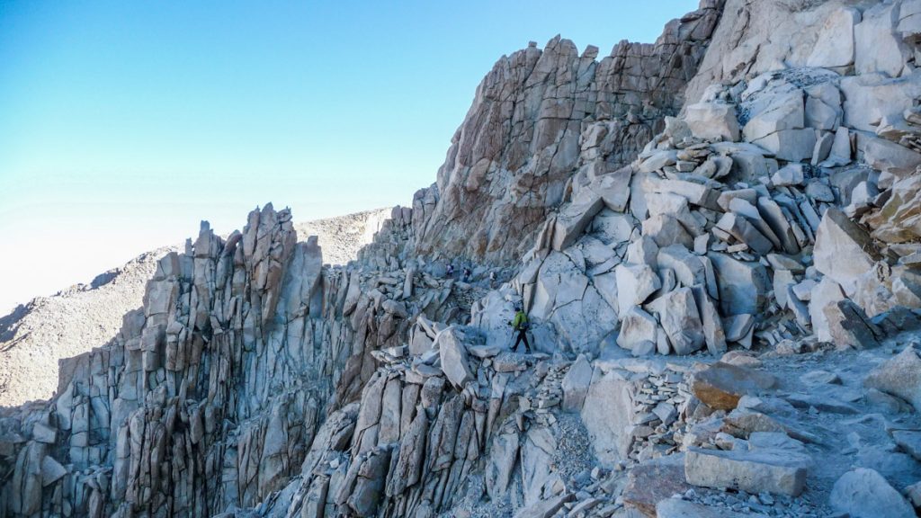
If you're continuing to the summit, you have to walk along a jagged path with sharp stones on all sides, and no trees. You're above the tree line. The trail here is not so steep, but the air is very thin, at 14,100-plus-feet, and although you only have a bit less than 400 more feet up to go, it's going to take the same energy as a 1,000 feet took from the access parking lot.
This shot is typical of the terrain on the west side of the Divide. This is looking north. You can see a man walking on the trail near the center of the photo:
The
source site says, "Peter in the green jacket."
This shot is looking uphill. You have to climb this thing. Fortunately, there is a trail.

Nearing the final climb, you face a sort of WALL of sharp boulders, which you have to climb up. At this point, you're glad someone else did this before you, because there is a trail cut in, where your steps can be somewhat like a stairway, but only approximately so.

The steepness of this final hill diminishes gradually, and as you approach the top, it turns into a kind of revelation-grade-pile-of-rocks, because with each step you take, your ability to see what's coming up grows, until you finally see the stone shack from the West side.
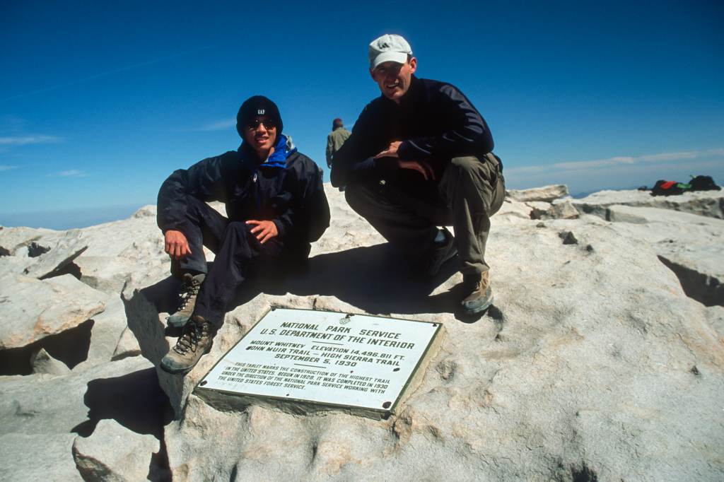
Kevin Yang made a better photo of the plaque:
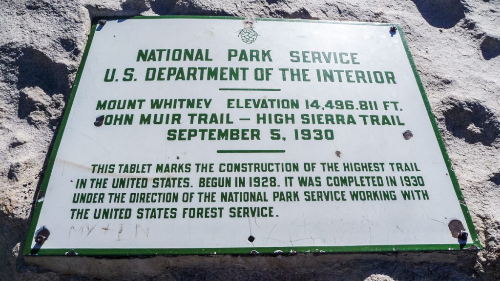
To the right of the stone cabin is more scattered rocks, and you'll find one car-sized boulder with a bronze plaque riveted to it, with a description of where you're at. Let's put it this way: it took you two days to climb up here, but the first guys to do it probably took a week or more, without any trails. They built the trail in 1930, after two years of work. That would be during the Great Depression. What do you suppose will be built during the next Great Depression?

Enjoy the panorama. It is a great idea to bring a 360-degree chart showing all the other peaks that are visible from there. Someone who knows their stuff can stand at the summit and name geological and man-made features for an hour. You might find it hard to believe how far you can see. your field of view stretches for about 300 miles. You can actually see a piece of Death Valley from there, but if you're in the Valley, you won't be able to see the mountain -- because the identifiable features of it are hidden behind other mountains. When you're standing on top of Mt. Whitney, you don't have that problem, because you can see a LOT of the mountain from the top of it.
I think this might be a shot from one of the many cliffs atop Mt. Whitney:
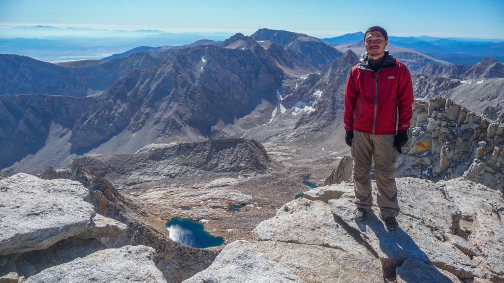
Notice the alpine lake in the valley below. These lakes are stocked with trout that have been hatched by commercial hatcheries. You need a fishing license to fish there. The catch, fried in butter (carry it uphill for two days!) in the open air, cannot be compared. You'll think you're no longer on planet earth. If they allowed resort development of select sites, they'd be backlogged for years with customers. But you can have it for "free" if you don't mind a little hard work. Tax free. So far.....
If you carefully look over the cliff, you can see straight down about 1,500 feet. Yes, there have been people who have found themselves quickly coming closer to the bottom of it, unfortunately. This is not a place to goof off. If you know what's good for you, don't go there with an idiot, and if you see anyone acting really goofy on the summit, KEEP AWAY from them. The thin air can make you light-headed and you might get a little silly, what with all the overwhelming vistas before you, but do try to keep your composure. Think about this well in advance so you condition your mind to be aware of the hazards of losing control of yourself.
Don't figure on being up there much after 1:00 pm, because you don't want to stay in the stinky shack if you don't have to.
The stove pipe visible on the outside seems to be a sort of remnant of a stove that used to be there, but apparently someone who had nothing better to do that day thought it would be funny to watch it crashing down the sheer face of the East side. Therefore, refugees don't have any more stove. And since the nearest outhouse is 2,500 feet below and several miles on the trail, certain someones have used the shack instead. That's another reason not to deliberately spend the night there. They should call it THE PENITENTIAL PINNACLE or PRELUDE TO PURGATORY or something like that.
Going down isn't nearly as difficult, but it can be a LOT more dangerous.
.

 Topic: Climbing MOUNT WHITNEY - 14,497 ft.el. - highest point in 48 States (Read 2647 times)