.
On the south side of the equator, the opposite condition exists, such that traveling eastward for example from Australia to Chile along the 33rd parallel south, the ship (or plane) must continually adjust its course by turning to the right a small amount. If no such correction is made, the course will drift north all by itself, automatically, and will take the vessel (or aircraft) to North America instead of to Chile.
.
Even though the course begins due east, parallel with the equator, and proceeds due east, parallel with the equator, the rudder must be turned to the right to keep the vessel from drifting toward the equator.
.
This is very basic navigation. All navigators who know anything at all about navigation, know this.
.
Putting all this together, the equator then appears as a straight line on the ground (or surface of the ocean), as far as the eye can see, and a very fast aircraft flying over the earth could follow this very straight line on the ground as if it were a line painted on an airport runway that goes on to the horizon.
.
However, all parallels north of the equator would appear as if a curved line on the ground. In the northern hemisphere, they would curve to the left ahead, and in the southern hemisphere they would curve to the right (both of these going eastward, again).
.
.
To be clear, all parallel "
baselines" in the northern hemisphere curve to the left up ahead if you're headed east, but if you turn around and face west, they all curve to the right up ahead in the distance.
.
Likewise, in the southern hemisphere, they curve to the right in the distance ahead if you're facing east, but (180 degrees behind you) when you turn around and face west, the parallel baselines in the distance curve to the left.
.
These lines of parallel are not great circles like the equator is, and that is why they curve in the distance toward the horizon. Any great circle route when viewed IRL, even with a telescope, appears as a straight line in the distance toward the horizon.
.
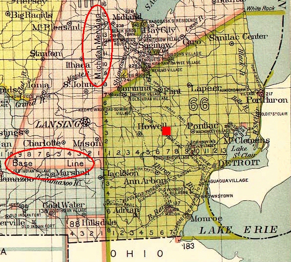
Here is a map showing the Michigan Base Line and Meridian, names circled in red. Look at your screen sideways and observe how Base Line curves ever so slightly to the left going east and to the right going west:
.
It's not too hard to imagine that without instruments it is pretty hard to see this curve because it is so gradual and broad. Remember, it is a curve with the center at the north pole, so with the naked eye, it's going to appear to be a straight line. You'd have to go to a high lookout point and see into the distance with a telescope on a VERY clear day, before you would see any curve.
.
The following map shows at least 3 Base Lines, two in California and one in Arizona. You can peek sideways at these as well and observe their curve right on your Internet device screen. The Baseline in San Bernardino County (the largest county in the entire United States) is the centerline of Base Line Street, "San Berdoo":
.

.
The next exhibit in evidence is a map showing the three Base Line and Meridians in California used to identify real estate property lines, San Bernardino Baseline and Meridian, Mt. Diablo Baseline and Meridian (near San Francisco) and the Humboldt Baseline and Meridian (near Humboldt), complete with longitude and latitude in degrees, minutes and seconds:

.
The centerline of Base Line Street, San Bernardino, is this very line used for land surveys.
.
It's kind of a crude map, but even here if you look from the side you can see the curvature of the two southern Baselines. The Humboldt one is too short, only about 100 miles on the map. By definition, the meridian lines, having the same bearing west of Greenwich, would be accurately shown as straight lines, however, since California is so long north to south, some curve has crept into the map in the San Berdo. region. Curiously, even though the Mt. Diablo Meridian is longer, it appears to be straighter on this map.
.

 Topic: 50 Plus Reasons The Earth Is Not Flat (Read 93391 times)